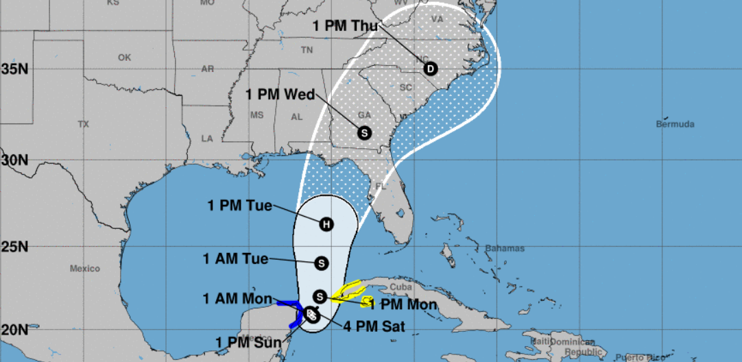
Gov. Ron DeSantis declared a state of emergency for 33 counties Saturday as Florida prepared for a tropical depression forecast to head toward the state’s Gulf Coast and become a hurricane.
The next named storm to form would be Idalia (pronounced ee-DAHL-ya).
The depression is first expected to become a tropical storm on Sunday but is expected to become a hurricane early next week, forecasters said.
The tropical depression formed a little after 4 p.m., and chances continue to increase that the system in the Caribbean will strengthen into a tropical storm, according to the National Hurricane Center.
The storm could continue strengthening as it reaches the Gulf on Tuesday, said Nick Carr, a meteorologist for the National Weather Service Miami, potentially reaching hurricane strength before it makes landfall.
There will be a “window” while the system is in the Gulf that may be conducive to it strengthening, Carr said, but it remains unclear how strong it could become.
“It could gain additional strength before it eventually makes landfall in the U.S, but it’s hard to guess what the ceiling would be at this point,” Carr said.
“Issuing this order today ensures communities have time to prepare for the storm system which could have impacts along the Gulf Coast next week,” DeSantis wrote on X, formerly known as Twitter.
The state of emergency does not currently include Broward, Palm Beach or Miami-Dade counties.
But South Florida could start seeing gusty winds, heavy rainfall and hazardous marine conditions beginning Monday and continuing through Thursday, according to the National Weather Service Miami.
The storm could also coincide with South Florida’s king tides next week, adding to already elevated tides and making flooding more likely, Carr said.
Tropical Depression Ten was stationary as of the 5 p.m. advisory, located about 65 miles northeast of Cozumel, Mexico, with maximum sustained winds of 30 mph. Little movement is expected through Sunday, before a slow northward motion begins Monday.
“The depression is forecast to strengthen during the next few days and could become a hurricane over the eastern Gulf of Mexico,” forecasters wrote, “bringing a potential of dangerous storm surge, heavy rainfall, and strong winds to portions of the west coast of Florida and the Florida Panhandle by the middle of next week.”
In its 5 p.m. Saturday advisory, the hurricane center said the center will move into the southeastern Gulf of Mexico by Monday.
The forecast path has the storm curling north toward Florida’s Gulf Coast by Tuesday or Wednesday.
A Tropical Storm Warning is in effect for the Yucatan Peninsula of Mexico from Tulum to Rio Lagartos, including Cozumel, while a Tropical Storm Watch is in effect for extreme western Cuba, including the provinces of Pinar Del Rio and the Isle of Youth.
Heavy rains are likely over western Cuba and the Yucatan Peninsula of Mexico, forecasters said.
The 33 counties included in the state of emergency are Alachua, Bay, Calhoun, Charlotte, Citms, Columbia, DeSoto, Dixie, Franklin, Gadsden, Gilchrist, Gulf, Hamilton, Hardee, Hernando, Hillsborough, Jefferson, Lafayette, Lee, Leon, Levy, Liberty, Madison, Manatee, Marion, Pasco, Pinellas, Polk, Sarasota, Sumter, Suwannee, Taylor, and Wakulla Counties.
The National Weather Service issued a statement on Friday recommending that Florida residents be ready for a soaking, which may start as early as this weekend.
“I’ve directed @KevinGuthrieFL & the FL Emergency Management team to prepare for a potential tropical system currently moving across the Yucatán Peninsula,” Gov. Ron DeSantis posted Thursday night on X, the social media platform previously known as Twitter. “Residents should remain vigilant and prepare for possible impacts early next week.”
On Friday, Florida’s Chief Financial Officer and State Fire Marshal Jimmy Patronis added his voice to the warnings to be prepared if the system intensifies.
“As Floridians are well aware, tropical storms are often unpredictable and can strengthen quickly,” he said in a news release. “I am urging Floridians to prepare now and to heed all watches and warnings from state and local officials. If a tropical storm is formed, it could make landfall Tuesday or Wednesday of next week with the potential to drop heavy amounts of rain which can lead to flooding.”
The reminders to be prepared come just as the state opens its second “sales tax holiday” of the year for hurricane-related supplies. Florida’s “disaster preparedness” tax holiday starts Saturday and continues through Sept. 8.
Meanwhile, Franklin became a hurricane Saturday morning and could become a major hurricane early next week. The storm is expected to move to the west of Bermuda on Monday and Tuesday. A disturbance several hundred miles to the east-northeast of the far eastern Caribbean could develop into a tropical depression early next week, while a tropical wave is forecast to move off the west coast of Africa.
The National Hurricane Center has been predicting an “above-normal” 2023 hurricane season as a result of ongoing record-breaking sea surface temperatures that continue to fight off the tempering effects of El Niño.
While sea surface temperatures have remained hot for longer than anticipated, El Niño’s effects, which typically reduce hurricane chances, have emerged more slowly.
The NHC, which operates under the National Oceanic Atmospheric Administration, has forecast 14-21 named storms, including 6-11 hurricanes, and two to five major hurricanes.
Source. Sunsentinel


